|
|
|||||||||||||||||||||||||||||
|
Buy online with PayPal |
|||||||||||||||||||||||||||||
|
New for 2014: Have a look at: With all the excitement about Richard III, you can find out here about the book that got everybody talking about where he was killed. |
|||||||||||||||||||||||||||||
|
ISBN 1-871344-06-9 Price: UK £5.95 International £7.95 |
|
|
|
 Category: Leicestershire Local History
|
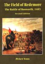
Peter Foss: It was the publication of Peter Fosss book that originally opened up the debate, and provided tangible documentary evidence that the approved version of the battle was not sustainable. It was always known that Market Bosworth itself was not the site of the battle. But for several hundred years it had been presumed that Ambion Hill, the site of Richard IIIs camp, had also been the battlefield. With Peters ground-breaking re-assessment of the site of the Battle of Bosworth, first published by Rosalba Press in 1990, and with the current edition published in 1998, an array of archive documents built up a compelling argument for rejecting the traditional plan of the battle and moving the site onto a flat, formerly marshy area around Dadlington parish, over a mile to the south-west. With the County Council sticking resolutely to their Ambion Hill version of events, it became clear that a major study was needed to resolve the question. The Battlefields Trust team, headed by Glenn Foard, have now gone public on some of the new finds and their locations. However, with new finds continuing to appear and further archaeological investigation proposed no one is yet prepared to be precise about the specifics of the battles location. News of the archaeological discoveries was first released in 2009. The information published in The Times of Oct 29th 2009 showed a broad target area rather further west than that identified in Peter Fosss putative plans. In February 2010 a major conference presented the locations of the finds in more detail. Most significant among these are an array of cannonballs and lead shot, plus a silver boar emblem. These were found where the four parishes of Dadlington, Stoke Golding, Shenton and Upton meet. The map here shows the Peter Foss version of 1998, with the newly published possible site shown as a yellow circle. It is the north-east part of the circle that appears to have contained the major finds. The archaeologists have not yet published their findings, so press reports of the conference remain the main source of detailed information. Powerpoint slides showing the find distribution were shown, and reported in most daily newspapers, such as the Daily Mail. The find of the boar emblem of silver, implying the presence of a member of King Richards retinue, has been rather journalistically reported as indicating the exact spot where Richard died. More generally, the cannonballs and shot have excited historians both for the evidence for the location of the battle, and what they can tell us about the development of medieval warfare. Lead cannonballs imply a use of mobile field artillery, which is indicated in at least two of the near-contemporary sources for the battle. Glenn Foard, describing the recent archaeological work, (www.bosworthbattlefield.com) explains, The reconstruction of the medieval landscape together with mapping of fen, moor and heath names led us to the general area where the four townships met - where Foss had suggested the battle took place. While pollen analysis followed by Carbon14 dating of peat deposits showed the marsh suggested by Foss had gone many centuries before the battle, we found another that proved to have continued into the medieval period. The second marsh (also identified by Foss in 1985), on the next stream along the Fenn Lane, is the area of the bulk of the finds. Using those finds to deduce how the battle ranged over the landscape is, of course, another challenge altogether. The Battlefield Heritage Centre has now opened its preliminary display, to show something of the current state of knowledge. But with much still open to question and interpretation, it is expected that the specifics of site and location will continue to alter and be refined for some time to come. It remains true that the most substantive historical account of the probable location of the Battle is provided by this book. Still available from Kairos Press, and on sale at the Bosworth Battlefield Centre, it continues to be the best detailed and authoritative opportunity to review the evidence for yourself.
Price including UK Postage: £5.95 This title is now out of print and unavailable. |

|
Contents Chapter One Chroniclers and Poets: The Problem of the Sources Chapter Two Eighteenth and Nineteenth Century Antiquarian Interpretations Chapter Three Hill, Plain and Marsh: The Topography of a Battle Chapter Four The Battle of Bosworth: a New Interpretation Notes Select Bibliography Appendix One: The Archaeological Problem Appendix Two: The Hinckley-Lyre Agreement (1283) Index
|
|
[Kairos Press] [About Us] [How to Order] [Catalogue] [Local History] [Natural History] [Local Interest] [News & Links] |